FriSki Join the beta

France

Val Thorens

The FriSki map of Val Thorens has 90 lifts and 227 named runs. Download it before you go and it works without signal, with your group live on the map and every turn called out by run name.

The map you download

Gondolas and cable cars
26
Chairlifts
33
Drag lifts and tows
12
Magic carpets
19
Green runs
23
Blue runs
99
Red runs
76
Black runs
25
Freeride runs
4

What you’ll hear on this map

  • In 200 meters, turn left onto the red run Mauriennaise.
  • Take the Combes lift.

FriSki says the run’s name and color in your headphones as you ski.

  • Novice
  • Easy
  • Intermediate
  • Advanced and expert
  • Lift and stations

Map data © OpenStreetMap contributors.
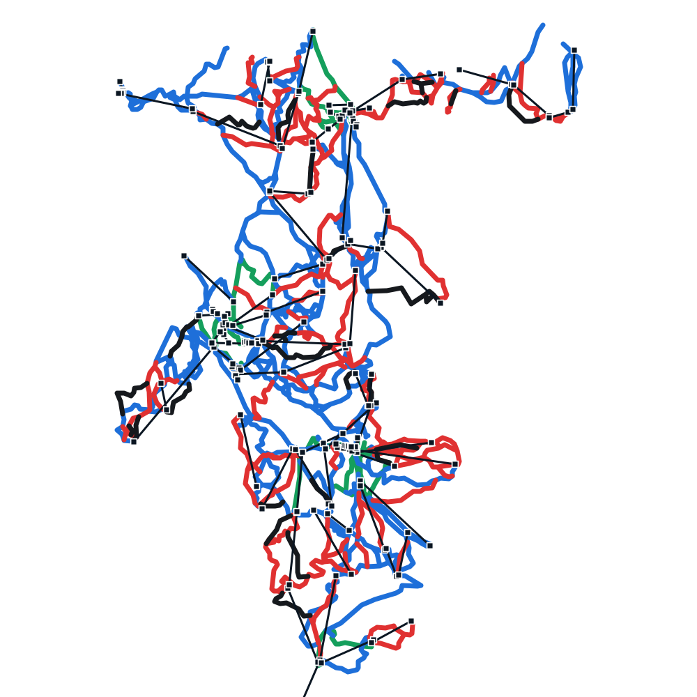
Val Thorens piste map drawn from FriSki map data: runs in their grade colors on white snow, lifts as dark lines with a square at each station.

Every lift and run on the map

90 lifts

Gondolas and cable cars 26

  • Bruyères 1
  • Bruyères 2
  • Cairn
  • Caron
  • Chalets
  • Cime Caron
  • Côte Brune
  • Croisette
  • Deux Lacs
  • Face Nord
  • Funitel 3 Vallées
  • Funitel Péclet
  • Grand Fond
  • Mont Vallon
  • Moraine
  • Pas du Lac 1
  • Pas du Lac 2
  • Plattieres
  • Pointe de la Masse
  • Preyerand
  • Roc 1
  • Saint Martin 1
  • Télécabine d'Orelle
  • Télécabine d'Orelle-Caron
  • Thorens
  • Tougnète 1

Chairlifts 33

  • 3 Vallées
  • Becca
  • Bettex
  • Boismint
  • Bouchet
  • Bouquetin
  • Cascades
  • Chanrossa
  • Cherferie
  • Combes
  • Doron
  • Granges
  • Lac Blanc
  • Marmottes
  • Menuires
  • Mont de la Chambre
  • Moutière
  • Mures Rouges
  • Peyron
  • Pionniers
  • Plan de l'Eau
  • Plan des Mains
  • Plein Sud
  • Portette
  • Reberty
  • Roc 2
  • Roc de Tougne
  • Roc Merlet
  • Rosaël
  • Saint Martin Express
  • Sunny Express
  • Tortollet
  • Tougnète 2

Drag lifts and tows 12

  • Aigle
  • Arolles
  • Caves
  • Jardin d'Enfants
  • Masse
  • Plateau 1
  • Plateau 2
  • Pyramides 1
  • Pyramides 2
  • Stade
  • Teppes
  • Village

Magic carpets 19

  • Biolley 1
  • Biolley 2
  • Bruyères
  • Campagnols
  • Castor Pollux
  • Doron
  • Marmottons
  • Musaraigne
  • Pelvoux
  • Plans
  • Preyerand
  • Reberty
  • Table verte
  • TPS VCS

Plus 5 with no name on the map.

227 named runs

Green 23

  • 2 Combes
  • Accès UCPA
  • Boulevard de la Masse
  • Boulevard du Doron
  • Boulevard du Hameau
  • Campagnols
  • Combe de Thorens
  • Espace Junior
  • Flocon
  • Fontanettes
  • Gentiane
  • La croix d'Antide
  • Little Himalaya (Yeti Park)
  • Montagnette
  • Musaraigne
  • Perdrix
  • Plan-Bouchet
  • Roc
  • Tourbière
  • Traversée Deux Lacs
  • Truite
  • Violette
  • Voie Lactée

Blue 99

  • 3 Marches
  • Access UCPA
  • Allée
  • Altiport
  • Bettex
  • Biolley
  • BK Park
  • Blanchot
  • Bleuets
  • Boardercross
  • Boulevard Cumin
  • Boulevard de la Becca
  • Boulevard de la Tête
  • Boulevard des Echauds
  • Boulevard des Girauds
  • Boulevard du France
  • Boulevard du Sunny
  • Boulevard du Téléphérique
  • Boulevard Goitschel
  • Boulevard Gury
  • Boulevard Rosaël
  • Bouquetin
  • Bouvreuil bleu
  • Boyes
  • Bruyères
  • Bumpy Run
  • Cairn
  • Chalets
  • Chamois
  • Chardonneret
  • Châtelet
  • Chemin des Vallons
  • Chocard
  • Choucas
  • Côte Brulée
  • Creux
  • Dalles
  • Enverses
  • Face Nord
  • Faon
  • Fémaz
  • Fond
  • Friendly Natural Park
  • Fun Slope
  • Gaston
  • Génépi
  • Gentianes
  • Grand Lac
  • Grive
  • Gros Tougne
  • Hermine
  • Jérusalem
  • Jn'bee
  • La Val Tho
  • La Voie de la boucle
  • Lac des Combes
  • Lac des Creux
  • Lagopede
  • Les Enverses
  • Les Marières
  • Les Plans
  • Lièvre
  • Linotte
  • Lory
  • Loy
  • Martre
  • Menuires
  • Mont de la Chambre
  • Montagnes Russes
  • Moraine
  • Mures Rouges
  • Niverolles
  • Ours
  • Paturages
  • Pelozet
  • Petits Creux
  • Peyron
  • Piste de Rosaël
  • Plan du Bouquet
  • Plan Mugnier
  • Plateau
  • Plein Sud
  • Pluviomètre
  • Pont de la Chasse
  • Preyerand
  • Pyramides
  • Rama
  • Retour Sud
  • Rossignol
  • Sittelle
  • Speedy Run
  • Tête Ronde
  • Tétras
  • Traversée de Montaulever
  • Vallons
  • Verdet
  • Village
  • Voie de la boucle
  • Voie de la Boucle

Red 76

  • 4 Vents
  • Adrien Théaux
  • Aigle
  • Aiglon
  • Allamands
  • Alouette
  • Alpage
  • Ardoises
  • Asters
  • Becca
  • Béranger
  • Blaireau
  • Boismint
  • Bouchet
  • Boulevard Boismint
  • Boulevard de la Lance
  • Boulevard des Coqs
  • Boulevard Lauzes
  • Bouvreuil rouge
  • Buse
  • Chardons
  • Chasse
  • Cherferie
  • Christine
  • Cime
  • Col de l'Audzin
  • Combe de Tougnète
  • Combe du Laitelet
  • Combe du Vallon
  • Combes
  • Coqs
  • Coraïa
  • Corniche
  • Crêtes
  • Croissant
  • Dahu
  • David Douillet Bas
  • David Douillet Haut
  • Éterlou
  • Evons
  • Falaise
  • Fouine
  • Fréderic Covili
  • Gypaète
  • Haute Combe
  • Jean Pachod
  • Julie
  • Lac Blanc
  • Lac de la Chambre
  • Les Grandes Combes
  • Longet
  • Marcassin
  • Marmottons
  • Mauriennaise
  • Médaille
  • Mouflon
  • Mur Rouge
  • Niverolle
  • Piste de la Cime Caron
  • Plan de l'Eau
  • Plan du Lac
  • Planes
  • Portette
  • Pouillard
  • Pramint
  • Rhodos
  • Roc Merlet
  • Rochers
  • Roches Grises
  • Skicross Jean-Fred Chapuis
  • Stade
  • Teppes
  • Trolles
  • Variante
  • Venturon
  • Vires

Black 25

  • Armoise
  • Arolles
  • Bartavelle
  • Campagnol
  • Cascades
  • Chanrossa
  • Combe de Caron
  • Combe de Rosaël
  • Cristaux
  • Dame Blanche
  • Écureuil
  • Freeride Lab
  • Goitschel
  • Grande Rosière
  • Ibex
  • Lac Noir
  • Léo Lacroix
  • Liberty Ride
  • Liberty Ride La Riondaz
  • Masse
  • Pylones
  • Rocher Noir
  • Sanglier
  • Stade Yannick Richard
  • Triton

Freeride 4

  • Bouchet - Lory
  • Caron-Lac du Lou
  • Itinéraire du Mont Vallon
  • Le Lac de Lou par la Masse

What you get on the mountain

Live group map

Your whole group, live

Every friend is a marker on the piste map that moves as they do. See who’s skiing, who’s on a lift and who’s stopped, so you know who’s below you and who’s still in the lift line.

Voice proximity alerts

“Maya is nearby, about 150 meters ahead”

When a friend comes within 100, 200 or 500 meters (you pick), FriSki tells you in your headphones. With alerts and spoken directions, you’ll rarely need to look at your phone.

Offline maps

No signal? The map still works

Download your resort on Wi-Fi before the trip, and its pistes, lifts and place names are saved on your phone. GPS doesn’t need a network, so your map and route keep working in a dead zone. Your friends reappear as soon as you have signal again.
Hear the way. See your friends. Keep skiing.

For Android and iPhone. Join the beta and we’ll email you when it’s your turn.

Join the beta Watch the app tour

Coming soon to the App Store Coming soon to Google Play

Got a question? Write to support@friski.co.